Keep exploring
Find even more resources on tides in our searchable resource database.
Have you ever wondered why the ocean ebbs and flows like clockwork? Understanding the tides and predicting their timing is important for many marine activities. This knowledge helps us navigate through coastal waterways, construct bridges, and even decide when it’s the best time to go fishing, surfing, or tidepooling.
Moonset over Monterey Bay National Marine Sanctuary. (Image credit: Douglas Croft)
Keep exploring
Find even more resources on tides in our searchable resource database.
What are tides?
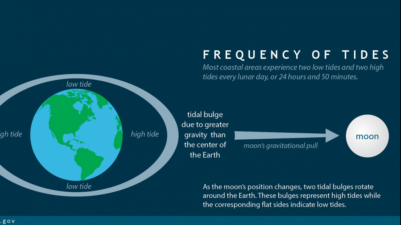
Tides are very long ocean waves that contribute to the rise and fall of sea levels. The most familiar evidence of the tides is the observed recurrence of high and low water on the coastline. Most tides are semidiurnal, meaning that each day there are two high and two low sea level points. These tides usually, but not always, alternate between highs and lows about every six hours. As low tide approaches, water recedes from the coast in an ebb current. When water moves toward the coast as high tide approaches, it is called a flood current.
Scientists predict and record tides using tidal charts (also known as tidal plots) and tables, which record wave height over time to identify high and low points. Since water levels are constantly changing, scientists use a reference, or datum, as a fixed reference point that represents "normal" water levels. The numbers shown on tidal charts are always relative to this specific datum. NOAA’s Center for Operational Oceanographic Products and Services provides the times and heights of high tide and low tide at more than 3000 locations along the U.S. coastline for navigation and safety. Always check local tidal charts to plan your coastal activities safely.
What causes tides?
Tides are set in motion by the gravitational pull of the Moon and the Sun on the Earth’s ocean. Landmasses and the Earth’s rotation add complexity, creating dynamic tidal patterns around the globe.
The Moon has the largest influence on the tides
In a simplified model, the tides are caused by the gravitational pull of the Moon and the Sun acting on the Earth. Picture the Earth as a perfectly spherical planet uniformly covered in water: As the Moon orbits the Earth, its gravitational pull acts unevenly across the planet. The Moon pulls more strongly on the side of Earth closest to it and more weakly on the far side. This difference, known as the tidal force, results in small but consistent forces that act over the vast area of the ocean. As a result, water is redistributed horizontally, forming two tidal bulges: one on the side closest to the Moon and one on the opposite side. As the moon orbits the Earth and the Earth rotates on its axis, the area under these bulges changes, causing different regions to experience its effects.
To visualize this, imagine you’re holding a rubber balloon. When you gently pull on it from both sides, the balloon stretches sideways. The parts you aren’t pulling on flatten slightly, because the material is being pulled away from those areas. This is similar to what the Moon’s gravity does to Earth’s ocean. These bulges are not caused by water being pulled upward by the Moon’s gravity, but by a horizontal stretching of the ocean surface due to these differential gravitational forces. However, while these gravitational forces generate the tidal bulges that cause the tides to move through the ocean, they do not control the actual timing of high or low tides at specific locations. Other, more regional forces, control when and how frequent high and low tide events occur.
The Sun’s gravity pulls with or against the Moon’s
The Moon has the largest influence on the tides, but the Sun plays a role as well. Although the Sun is much larger than the Moon, it is also much farther away from Earth. On Earth, the Sun’s gravitational force on the ocean is weaker than the Moon’s, but it still can influence the tides.
- Neap tides: When the gravitational force of the Sun and Moon work against each other — when there is a half Moon — this creates weaker tides that exhibit the smallest difference between high and low water levels.
- Spring tides: When the two gravitational forces work together — during a full or new Moon — this creates stronger tides that exhibit the largest tidal range.
- Perigean spring tides: Several times each year, a spring tide will occur around the date when the Moon is also at its perigee, or closest position to the Earth. This will cause even stronger tides, popularly known as king tides.
Landforms and Earth’s rotation add complexity
In reality, tides around the world are shaped by many complex patterns. Because the Earth isn’t a perfectly smooth sphere, landmasses interrupt the flow of water. The shape of coastlines defines the ocean basins, causing the waves of water created by the astronomical forces to “bounce off” of and reflect in unique ways. To visualize this, imagine you're in a bathtub, pressing down on the water repeatedly with your hands. The water isn’t just uniformly pushed away by your hand, but sloshes back and forth across the tub as it bounces off of you, the bathtub edge, and even your rubber ducky. Driven by the gravitational pull of the Moon, and shaped by Earth's rotation and landmasses, the ocean sloshes around its basins in similar complex patterns.
Further complicating tidal movement, the Coriolis effect from the Earth’s rotation causes water in steady motion to turn to the right in the Northern Hemisphere and to the left in the Southern Hemisphere. The shape of the coastline, the local seafloor depth and topography, local wind and weather patterns, and other factors also significantly impact the height and the timing of the tides. The inertia of water and its friction with the seafloor cause a delay between when the force is exerted and when high tides are observed. This phenomenon, known as tidal lag, can be hours or even close to an entire day in some parts of the world. As a result of the combination of these factors, the type and frequency of tides may be different in different areas:
- Semidiurnal tides: Some coasts experience two high tides per day with heights that are about the same.
- Mixed semidiurnal tides: Some coasts experience two high tides per day with varying heights.
- Diurnal tides: Some coasts experience only one high tide per day.
- Some areas, like the U.S. Gulf Coast, may shift between diurnal and mixed semidiurnal tides during the month or year.
The model above shows the complicated patterns of high and low tides across the planet, visualized here responding to just the Moon’s daily influence. You may notice that the high tides are not always synchronized with when the moon and sun are directly overhead and actually can vary even at the same longitude. Many factors go into the actual location and timing of high and low tides, including tidal lag, the way water bounces around landforms and basins, and weather creating its own patterns.
Curious about taking a deeper technical look at the tides? This resource from the National Ocean Service provides detailed diagrams and mathematical explanations of the forces acting on the global ocean.
How do we predict tides?
Predicting tides has always been important to people who look to the sea for their livelihood, such as fishermen, sailors, ecologists, and coastal engineers. The process involves first recording water levels in one location for a long time, at least 30 days, but preferably over a year or longer. We can analyze the data to mathematically identify the “harmonic constituents" that can then be used to predict tides at that location in the future based on what we know about the positions of the Earth, Moon, and Sun through astronomy.
NOAA’s history of tide prediction dates back to the days of the U.S. Coast Survey, a predecessor to NOAA. Before the mathematical breakthroughs that made current-day tide prediction possible, the U.S. Coast Survey installed tide gauges and published tidal predictions using the lunitidal interval method. In 1867, Sir William Thomson (Lord Kelvin) introduced the harmonic method for tide predictions. The calculations were complicated and time-consuming, so the U.S. Coast and Geodetic Survey, as it was called at the time, employed people to work as “computers” to do these calculations.
They also developed analog computers (mechanical machines powered by cranks and gears) to automate the work. The Ferrell Tide Predicting Machine operated from 1881-1911. Tide Predicting Machine No. 2 (nicknamed “Old Brass Brains”) operated from 1912-1965, and used 37 harmonic constituents that are still used today. This new technology led to more detailed tidal predictions and played an important role in decreasing shipwrecks.
Since Tide Predicting Machine No. 2 was retired, the National Ocean Service has continued to provide accurate and reliable tidal predictions using similar mathematical principles. Today, data is processed using sophisticated modern computers coupled with sensors located across the United States and on select Pacific and Caribbean Islands. NOAA Tide Predictions allow users to generate tide predictions for up to two years in the past or future, at any of 3,000+ locations.
NOAA’s Brass Brains, officially known as Tide Predicting Machine No. 2, is an early 20th century mechanical computer used to make tide predictions for the United States.
What are the main types of intertidal environments?
Tides are important not only to human activities, but to marine organisms, too! The tidal cycle has played a big role in developing environments along the coasts, resulting in unique and biodiverse habitats adapted to the floods and ebbs of the ocean.
Rocky intertidal
The rocky intertidal zone is characterized by rock formations that experience both total exposure and submersion throughout the tidal cycle. During low tide along rocky shorelines, crevices between rock are filled with seawater, creating tidepools. These tidepools are teeming with diverse sea creatures left by the escaping tide. From barnacles to snails to urchins and beyond, these organisms are adapted to the extremes of intertidal life. Many cling to rocks to stay put and survive the changing variables of heat, water, air, turbulence, and salinity variation between high and low tide. Low tide is the perfect time for humans to explore these unique pockets of resilient marine life. Make sure to research guidelines specific to your region, check out our tidepooling tips, and always tidepool responsibly!
Salt marshes
Salt marshes are coastal wetlands that are flooded and drained by salt water brought in by the tides. They are composed of decomposing plant matter called peat, creating a dense, hypoxic (low oxygen) environment. These conditions slow decomposition, storing carbon in the leaves and roots of marsh plants. Salt marshes have both deep pools and shallow salt pannes. Salt pannes are shallow depressions that retain flooding seawater for very short periods of time. As the seawater evaporates, salt is left behind and accumulates over time. In contrast, pools tend to retain water throughout tidal cycles. Salt marshes are home to a diversity of species throughout their high to low zones. Organisms are adapted to the high salinity environment, such as glasswort, smooth cordgrass, salt marsh snails, and green crabs.
Mangrove forests
Mangrove forests grow at tropical and subtropical latitudes near the equator. Mangrove trees grow in hypoxic soils where slow-moving waters allow fine sediments to accumulate. These plants can be recognized by their dense tangle of prop roots that allows the trees to sit above the water. This tangle of roots helps to slow the movement of tidal waters, causing sediments to settle out of the water and build up the muddy bottom. This process helps stabilize the coastline, reducing erosion from tides and other waves.
Sandy beaches
Sandy beaches tend to be relatively open areas composed of fine or coarse sands that experience significant wave and wind energy. Some beaches may stretch wide and flat, while others may consist of sloped dunes. Sand is transported to the shore by the ocean and rivers over large timescales, constantly changing a beach’s form. The high energy and changing environment is unsuitable for rooted and attached organisms, but between grains of sand, zooplankton like diatoms and copepods can be found. Burrowed underneath the sand, thriving communities of invertebrates like crustaceans, mollusks, and worms make their home as well.
Mud flats
Mud flats (sometimes referred to as tidal flats) are low-lying areas in salt marshes covered with large, flat expanses of mud. They are composed of fine silts and clays deposited by the ocean and rivers. Mud flats harbor burrowing creatures including clams, mussels, oysters, fiddler crabs, sand shrimp, and bloodworms. They also act as an important breeding ground for several species of fish. Mud flats are hypoxic (oxygen poor), which promotes the growth of bacteria, causing the rotten-egg smell known to accompany this environment.
How are tides and flooding related?
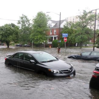
Have you ever heard of sunny-day flooding, nuisance flooding, or king tide flooding? These are all different phrases used to describe flooding caused during high tides. As sea levels rise over time due to land height changes and effects of a warming climate, the reach of high tides grows more of a concern.
Sea level rise leads to increased coastal flooding, even in the absence of storms or heavy rainfall, endangering coastal communities around the world. Understanding sea level rise projections can inform communities about current and future vulnerabilities, and help them make smart decisions to keep people and property safe.
Report projects a century of sea level rise in 30 years.
EDUCATION CONNECTION
Many people have casually observed tides, which makes them a good fit for phenomenon-based learning. Understanding tides can be interdisciplinary, bringing in concepts across STEM disciplines including Earth and space science, physical science, life science, math, and engineering. Tides also have a fascinating history and many human connections, including why it’s important for people to monitor tides, how we can use tides as an energy source, and how climate change impacts tides. High and low tide predictions are data points that educators can easily use to introduce environmental data, graphs, and geography. Students can compare tide prediction data and observations from tide gauges to open a door to conversations about other factors that influence water levels, like rain and wind.
Glossary
Definitions of some of the terms used in this resource collection.
Coriolis effect
The deflection of air and water masses towards the right in the northern hemisphere and to the left in the southern hemisphere due to Earth’s rotation and the conservation of angular momentum1
datum
An abstract coordinate system with a reference surface (such as sea level) that serves to provide known locations to begin surveys and create maps2
diurnal tides
A tidal cycle in which one high and one low tide occurs every lunar day
ebb current
The movement of water away from the shore as the tide recedes
flood current
The movement of water toward the shore as the tide rises
friction
The resistive force of one object on another object's relative movement when in contact with the first object
hypoxic
Deficient in oxygen3
inertia
An object's or system's natural tendency to resist changes in its state of motion or condition4
king tides
A popular, non-scientific term people often use to describe exceptionally high tides, such as perigean spring tides5
mixed semidiurnal tides
A tidal cycle in which two high and two low tides of different sizes occur every lunar day
neap tides
Comparatively weak tides that occur when the gravitational force of the Sun and Moon work against each other, such as when there is a half Moon
perigean spring tides
Strong tides that occur when a spring tides coincides with the date of when the when the Moon is at its perigee6
perigee
The moon’s closest position to Earth
salt pannes
Shallow depressions that retain flooding seawater for very short periods of time
semidiurnal tides
A tidal cycle in which two high and two low tides of approximately equal size occur every lunar day
spring tides
Comparatively strong tides that occur when the gravitational force of the Sun and Moon work together, such as when there is a full or half Moon
tidal chart
Graphs that provide a listing of the times and heights of the daily high and low tide predictions, or hourly interval tidal height values, for a particular location
tidal force
The gravitational pull exerted primarily by the Moon (and to a lesser extent, the Sun) across Earth's surface
tidal lag
The delay between the Moon's overhead position and the actual occurrence of high tide
tidepools
An isolated pocket of seawater found in the ocean’s intertidal zone7
Keep exploring
Find even more resources on tides in our searchable resource database.