While wind damage from thunderstorms often makes people think of tornadoes, damaging “straight-line” winds are actually much more common than tornadoes. In fact, many people often erroneously attribute straight-line wind damage to tornadoes.
The development of damaging winds begins with the downdraft.
As air rises, it cools to the point of condensation, where water vapor forms the tiny water droplets comprising cumulus clouds. Near the center of the updraft, the particles begin to collide and coalesce, forming larger droplets. This continues until the rising air can no longer support the ever-increasing size of the water drops.
Once the rain drops begin to fall, friction pulls against the rising air, and it too begins to fall towards the surface. Some of the falling rain will evaporate. Through evaporation, heat energy is removed from the atmosphere, cooling the air associated with the precipitation. As a result of this cooling, the density of the air increases, causing it to sink toward the Earth. The cooled air and falling precipitation marks the development of the downdraft, which is located alongside the updraft in a mature thunderstorm.
When this dense rained-cooled air reaches the surface, it spreads out horizontally, with the leading edge of the cool air forming a gust front. The gust front marks the boundary of a sharp temperature decrease and increase in wind speed. The gust front can act as a point of lift for the development of new thunderstorm cells, or it can cut off the supply of moist unstable air to older cells, ending convection.
Downbursts are defined as strong winds produced by a downdraft over a horizontal area up to 6 miles (10 kilometers). Downbursts are further subdivided into microbursts and macrobursts.
Microbursts and Macrobursts

A microburst is a small downburst with an outflow, defined as cooled air quickly moving outward from the storm, less than 2½ miles (4 kilometers) in horizontal diameter and lasting only 2-5 minutes. Despite their small size, microbursts can produce destructive winds up to 168 mph (270 km/h). They create hazardous conditions for pilots as well and have been responsible for several disasters:
- As aircraft descend into the airport (above), they follow an imaginary line called the "glide slope" (solid light blue line) to the runway.
- Upon entering the microburst, the plane encounters a "headwind" – an increase in wind speed over the aircraft. The stronger wind creates additional lift, causing the plane to rise above the glide slope. To return the plane to the proper position, the pilot lowers the throttle to decrease the plane's speed, thereby causing the plane to descend.
- As the plane flies through to the other side of the microburst, the wind direction shifts and is now a "tailwind" as it is coming from behind the aircraft. This decreases the wind over the wing, reducing lift. The plane now sinks below the glide slope.
- The tailwind remains strong and, even with the pilot applying full throttle to try to increase lift again, there may be little, if any, room to recover from the rapid descent, causing the plane to crash short of the runway.
Since the discovery of this effect in the early to mid-1980's, pilots are now trained to recognize microbursts and take appropriate actions to prevent accidents. Many airports are also now equipped with tools to detect microbursts and warn aircraft of their occurrences.
A macroburst is larger than a microburst, with a horizontal extent more than 2½ miles (4 km) in diameter. A macroburst is not quite as strong as a microburst but can still produce winds as high as 130 mph (210 km/h). Damaging winds generally last longer, from 5 to 20 minutes, and produce tornado-like damage, up to an EF-3 scale.

In wet, humid environments, macrobursts and microbursts will be accompanied by intense rainfall at the ground. If the storm forms in a relatively dry environment, however, the rain may evaporate before it reaches the ground, and these downbursts will be without precipitation, known as dry microbursts.
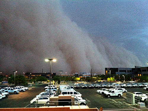
In the desert southwest, dust storms are a rather frequent occurrence due to downbursts. The city of Phoenix, AZ, typically has 1-3 dust storms each summer due to the cooler dense air spreading out from thunderstorms.
On July 5, 2011, a massive dust storm resulted in widespread areas of zero or near-zero visibility in Phoenix. The wind that produced this storm was generated by downbursts from thunderstorms with winds up to 70 mph (110 km/h).
Heat Bursts
Dry downbursts are also responsible for a rare weather event called "Heat Bursts". Heat bursts usually occur at night, are associated with decaying thunderstorms, and are marked by gusty, and sometimes damaging, winds, combining a sharp increase in temperature and a sharp decrease in dew point (humidity).
The process begins higher in the atmosphere than for other downbursts. A pocket of cool air aloft forms during the evaporation process, as for any downburst. But as the precipitation falls, it fully evaporates before reaching the ground. The cool dense air sinks by the pull of gravity, but since there are no rain drops to absorb heat, the air then warms due to compression.
The air becomes quite hot and very dry. Temperatures generally rise 10 to 20 degrees in a few minutes and have been known to rise to over 120°F (49°C) and remain in place for several hours before returning to normal. One such heat burst occurred in Wichita, KS on June 9, 2011.
Derechos
If the atmospheric conditions are right, widespread and long-lived windstorms associated with a band of rapidly moving showers or thunderstorms can result. The word "derecho" is of Spanish origin and means “straight ahead”. A derecho is made up of a family of downburst clusters and, by definition, must be at least 240 miles in length. Learn more about derechos.


