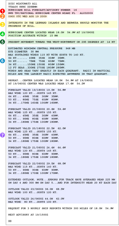
The Tropical Cyclone Forecast/Advisory is issued when meteorological data indicates that a tropical or subtropical cyclone has formed. Special advisories or forecasts are issued whenever unanticipated significant changes occur.
Once a system develops to the tropical depression stage (maximum sustained winds of 34 kt (38 mph/61 km/h) or less), this product is issued every six hours until the cyclone either becomes extra-tropical or weakens to below tropical depression status.
Note: All wind speeds in the forecast advisory in given in knots (nautical miles per hour). All distances are given in nautical miles. To convert knots to mph or nautical miles to statue miles multiply values by 1.15.

- The title of the product and the office of origination.
- Forecast/Advisories are issued on all Atlantic and eastern Pacific tropical and subtropical cyclones every six hours at 0300, 0900, 1500, and 2100 UTC (learn about UTC time). Special Forecast/Advisories may be issued at any time due to significant changes in warnings or the cyclone.
- There may be a "heads-up" statement alerting those that could possibly be affected by the storm but who are not yet under any watch or warning. This portion will be omitted should the tropical cyclone not be a threat to any landmass.
- The date/time and location (tenths of a degree) of the center of the storm.
- Direction (to the nearest 5°) and speed (in knots) of the storm's forward motion.
- Current location information includes:
- An estimate of the lowest atmospheric air pressure (in millibars).
- Diameter of the storm's eye (if any or if known, in nautical miles).
- Maximum sustained wind speed along with the maximum speed of gusts (in knots).
- Radii of the maximum wind in four quadrants in three categories: ≥64 kt, ≥50 kt, ≥34 kt. The quadrants are defined as NE (0°-90°), SE (90°-180°), SW (180°-270°), and NW (270°-360°). Also, the extent in each quadrant of seas at least 12 feet high is provided, if any.
Note: Since winds and seas vary greatly around a tropical cyclone, these quadrants indicate the greatest extent of the winds and/or seas are expected.
- The forecast will contain 12-, 24-, 36-, 48-, 72-, 96-, and 120-hour tropical cyclone forecast positions and wind radii. Due to forecast uncertainties, at 48- and 72-hour forecasts, the radii for the 64 kt winds are not provided. That is not necessarily to imply the storm is expected to decrease.
Learning Lesson: Quadraphonic Wind

