An official website of the United States government
Official websites use .gov
A .gov
website belongs to an official government organization in the United States.
Secure .gov websites use HTTPS
A lock (
) or https:// means you’ve safely connected to the .gov website. Share sensitive information only on official, secure websites..
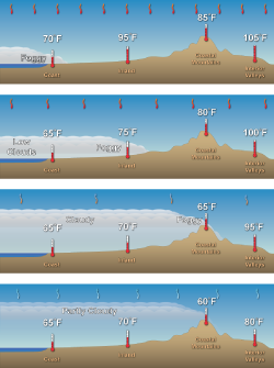
Strong downward motion from upper level high pressure squashes the marine layer and keeps is confined to the coast. Inland temperatures are high.
A weakening of the downward motion aloft allows for the marine layer to move further inland and a little lower inland temperatures.
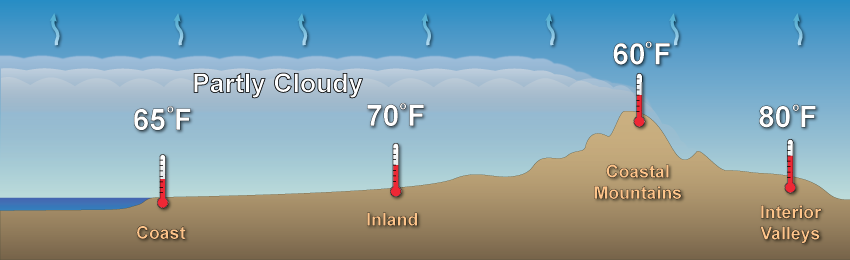
Slight upward motion in the upper atmosphere allows the marine layer to move well inland but tall coastal mountains inhibit further
penetration. Inland valley temperatures will continue to decrease slightly due to the overall upward motion of air.
Strong lifting aloft considerably deepens the marine layer allowing cooled marine air to spill over coastal mountains into the inland valleys.
Somewhat similar to the sea breeze, the marine layer also results from the interaction between air masses of different temperatures and densities. However, unlike the east coast sea breeze, which reforms almost every day due to the rise and fall of heated and cooled air in the summer atmosphere, the west coast marine layer can persist for days or weeks due to a process called a temperature inversion. This is particularly seen along the coasts of Central and Southern California.
Strong downward motion from upper level high pressure squashes the marine layer and keeps is confined to the coast. Inland temperatures are high.
A weakening of the downward motion aloft allows for the marine layer to move further inland and a little lower inland temperatures.
Slight upward motion in the upper atmosphere allows the marine layer to move well inland but tall coastal mountains inhibit further
penetration. Inland valley temperatures will continue to decrease slightly due to the overall upward motion of air.
Strong lifting aloft considerably deepens the marine layer allowing cooled marine air to spill over coastal mountains into the inland valleys.