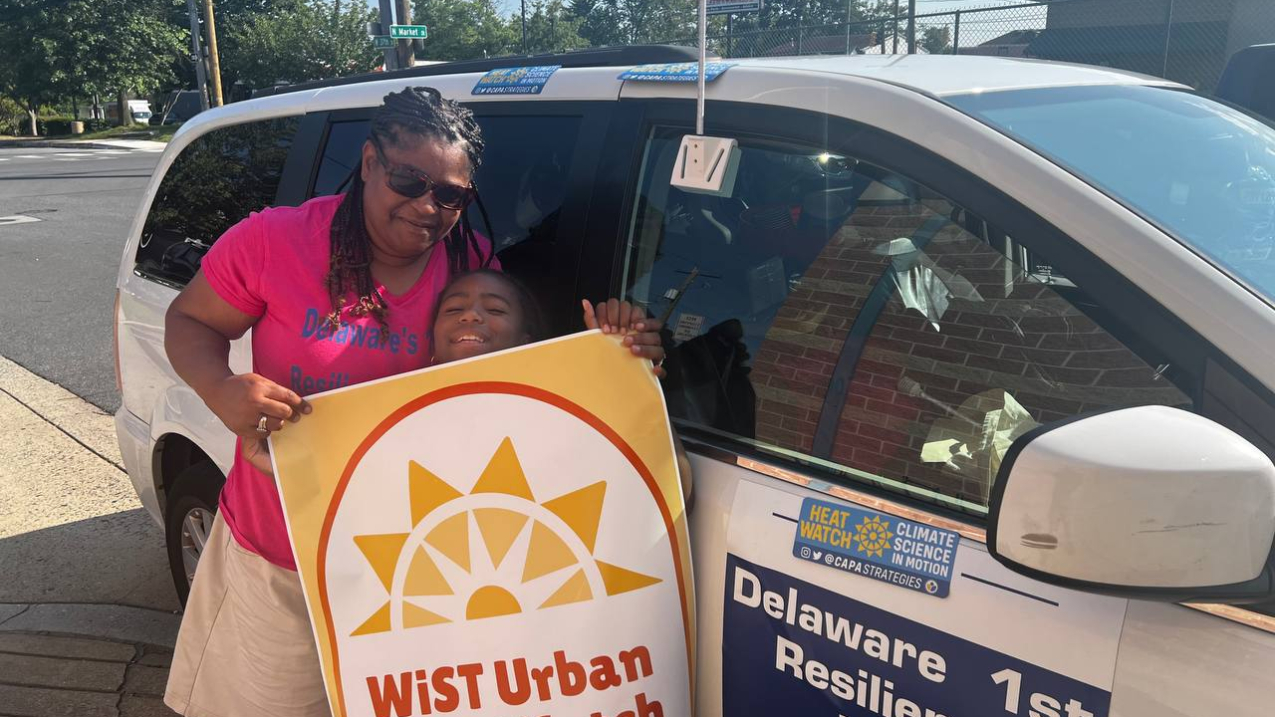
Stacey Henry, founder of the Delaware Resilience Hub, and her daughter, Mylee, volunteered to collect temperature, humidity, time and location data for the 2023 NOAA-supported Urban Heat Island mapping campaign in Wilmington, Delaware and surrounding townships. They joined other volunteers who attached sensors to their cars to collect the data that was used to create a detailed map of the hottest areas in their community. University of Delaware Climate HUB helped coordinate the volunteer campaign in July 2023. (Image credit: Keihan Hassanzadehkermanshahi)
This summer NOAA, in partnership with the U.S. Departments of Health and Human Services (HHS) and Housing and Urban Development (HUD), as well as community scientists, will map the hottest neighborhoods in 14 U.S. communities and four international cities. Identifying these areas, called urban heat islands, helps communities take action to reduce the health impacts of extreme heat and provides cooling relief for those living in the hottest areas.
“HUD is pleased to join our federal partners in support of this campaign to map communities throughout the country most impacted by extreme heat,” said HUD Acting Secretary Adrianne Todman. “This mapping campaign is an important step to understand how extreme heat affects the health, safety and quality of life of our communities. At HUD, this information is critical as we develop programs to support our core mission of creating strong, sustainable, inclusive communities.”
“From manufacturing to clean energy initiatives, President Biden’s Investing in America agenda is about transforming our country for the better,” said U.S. Deputy Secretary of Commerce Don Graves. “As climate change accelerates, so does our need to understand where and who is most impacted. By working together with our partners in government, science and academia, this new initiative will help us paint a clearer picture of what cities across the globe are at the greatest risk — and how our resources to mitigate that risk can be most efficiently and effectively mustered.”
“As extreme heat affects people’s health more and more across the United States and around the world, programs like NOAA’s Urban Heat Island mapping campaign provide essential information to guide relief and risk mitigation efforts, and to make sure resources get to the neighborhoods at greatest risk,” noted HHS Assistant Secretary for Health ADM Rachel Levine, who oversees the HHS Office of Climate Change and Health Equity partnering on this project.
Now in its eighth year, the NOAA Urban Heat Island mapping campaign addresses extreme heat, the number one weather-related cause of death in the U.S. for the last three decades. Summer 2023 was Earth’s hottest on record, and communities across the globe felt this heat, impacting health, infrastructure, agriculture and more.
Urban heat islands, areas with few trees and more pavement that absorbs heat, can be up to 20 degrees Fahrenheit hotter than nearby neighborhoods. To map these areas and collect the data necessary to protect disproportionately affected communities, the NOAA Climate Program Office (CPO), the interagency National Integrated Heat Health Information System (NIHHIS), HHS, HUD and CAPA Strategies, LLC offsite link will work with each of the participating communities.
"It's exciting to see how communities have used their urban heat maps to strategize placement of trees and shade structures, determine areas in need of more outreach and inform overall city resilience plans," said NOAA Administrator Richard Spinrad, Ph.D. "This year, partnering with HUD and HHS will allow the program to expand and provide even more resources to communities."

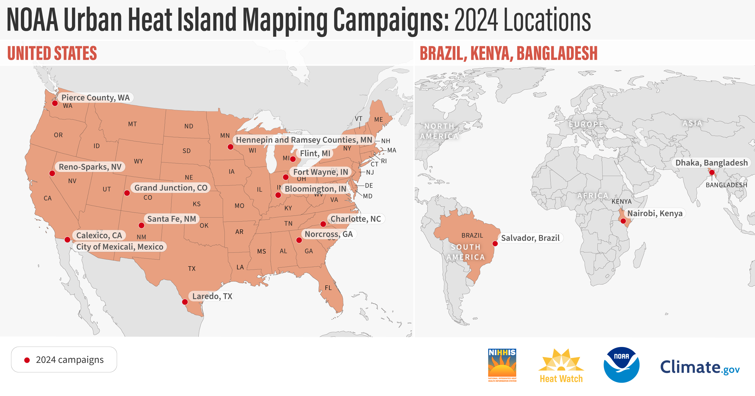
Communities chosen for the 2024 program are: Bloomington, Indiana; Calexico, California; Charlotte, North Carolina; Flint, Michigan; Fort Wayne, Indiana; Grand Junction, Colorado; Hennepin and Ramsey Counties, Minnesota; Laredo, Texas; Pierce County, Washington; Reno and Sparks, Nevada; Santa Fe, New Mexico; and Unincorporated Norcross, Georgia. The international campaigns will take place in Mexicali, Mexico; Dhaka, Bangladesh; Nairobi, Kenya; and Salvador, Brazil. International campaigns were previously completed in Freetown, Sierra Leone, Rio de Janeiro, Brazil, and Santiago, Chile.
Local campaigns in the U.S. and abroad do not receive direct funding from NOAA. Instead, over the past seven years, NOAA has funded CAPA Strategies, a U.S. company, to provide science support, including sensors, planning assistance and map creation based on data collected by community volunteers. CAPA Strategies has supported more than 70 community-led urban heat island mapping campaigns in the U.S. and international communities by recruiting volunteers to conduct heat data. Communities also bring their own financial and in-kind support from partners that include nonprofit organizations, city government agencies, schools, science museums and international foundations.
While the emphasis of the program is on urban heat island mapping in U.S. cities, a smaller number of international campaigns benefit U.S. communities because they broaden the scope of lessons that can be learned from how other countries tackle extreme heat. They also enable the U.S. to share best practices more broadly.
Using heat sensors mounted on their own cars, volunteer community scientists, led by a team of local partners in each city, traverse their neighborhoods in the morning, afternoon and evening on one of the hottest days of the year. The sensors record temperature, humidity, time and the volunteers’ location every second. CAPA's end-to-end program, including sensor technology, community engagement, analysis and modeling allows communities to develop hyper-local descriptions of where the hottest parts of their community are and strategize mitigation options specific to each region of the country.
The cities and counties selected this year have a range of experiences with extreme heat, but each is looking for equitable ways to implement cooling solutions in their communities. For example, Pierce County, Washington, was one of the many counties in the Pacific Northwest that faced an unprecedented heat wave in June 2021. Hundreds of lives were lost in the region, including 159 deaths in Washington offsite link and 29 deaths in Pierce County. Throughout the state, high temperatures buckled roadways, melted train power lines and damaged other infrastructure, while also scorching forests that were not adapted to the extreme conditions.
During the 2023 urban heat island campaigns, 942 community scientists took more than one million measurements in 19 U.S. communities. The data and maps from the campaigns are open access and available on HEAT.gov.
Previous and current communities participating in the UHI campaigns are part of a community of practice where they are able to share best practices and network with other cities addressing extreme heat. Many of the communities have implemented cooling solutions based on the heat maps, including securing federal funding for tree planting initiatives, establishing cooling centers, developing heat action plans, educating the public on heat and more.
NOAA’s heat island mapping program is part of the Biden Administration’s Justice40 initiative, a whole-of-government effort to ensure that federal agencies work with states and local communities to make good on President Biden’s promise to deliver 40% of benefits from federal investment in climate and clean energy to disadvantaged communities. When evaluating applications for the 2024 heat island mapping campaigns, the NIHHIS team gave significant weight to applications emphasizing their commitment to addressing environmental justice.
To keep up with the summer 2024 campaigns, subscribe to the Heat Beat Newsletter offsite link, check out the NIHHIS website and follow #UrbanHeatMaps2024 on social media.
Climate, weather, and water affect all life on our ocean planet. NOAA’s mission is to understand and predict our changing environment, from the deep sea to outer space, and to manage and conserve America’s coastal and marine resources.


