On December 26, 2004, an extremely powerful earthquake off the coast of the Indonesian island of Sumatra in the Indian Ocean generated a devastating tsunami.
This tragic event raised awareness about the threat posed by tsunamis to coastal communities around the world and led to significant advances in tsunami detection, forecasting, warning, and preparedness.
The Earthquake
The magnitude 9.1 earthquake was one for the record books and stands today as the third largest in the world since 1900.
It occurred 18.6 miles (30 kilometers) below the ocean floor along a reverse fault in the Sunda trench where the Indian plate (part of the Indo-Australian plate) subducts beneath the Burma plate (a minor tectonic plate or microplate). The length of the rupture was roughly 800 miles (1,300 kilometers), similar in length to California.
The shaking was felt not only in Indonesia, but also in Bangladesh, India, Malaysia, the Maldives, Myanmar, Singapore, Sri Lanka, and Thailand. The earthquake caused severe damage and casualties in Indonesia (Northern Sumatra) and in India (the Andaman and Nicobar Islands).
The Tsunami

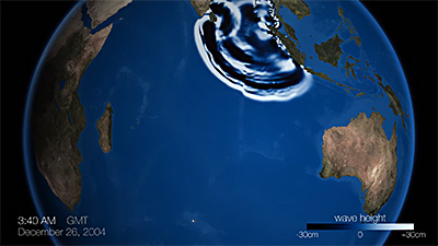
The tsunami that followed had catastrophic impacts throughout the Indian Ocean. Once generated, the tsunami radiated outward in all directions, striking the coasts of Indonesia and India's Andaman and Nicobar Islands within 20 minutes of the earthquake and the northeastern coast of Somalia in Africa seven hours later.
Wave heights and inundation distances varied throughout the region based on location relative to the source earthquake as well as the depth of the ocean, the elevation of the coast, and other features of the land both above and below the ocean. In Indonesia's Aceh province in Northern Sumatra, waves reached 167 feet (51 meters) and caused flooding up to three miles (five kilometers) inland.
On the other side of the ocean, in Somalia, waves ranged in height from 11 to 31 feet (3.4 to 9.4 meters). The tsunami was also observed on over 100 coastal water-level stations in the Atlantic and Pacific Oceans, making it a global tsunami.
While deadly tsunamis had happened in the Indian Ocean region (5% of the tsunamis between 1900 and 2017 occurred in the Indian Ocean), the last major tsunami was in 1883. So at the time of the event, there was little public awareness about tsunamis, and there was no official tsunami warning system.

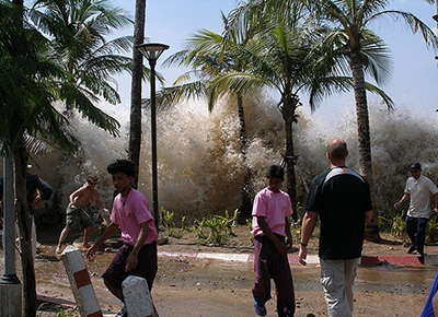
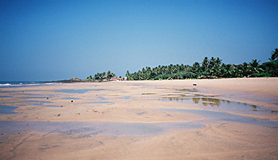
Natural tsunami warnings included the earthquake (close to its source), withdrawal of the sea, and unusually large but not damaging initial waves. Unfortunately, these were not widely understood as warnings, and many witnesses to the event rushed to the water to explore the exposed ocean floor or continued with their daily activities.
In some cases, where tsunami knowledge existed and was used, like in small island communities where stories about tsunamis had been passed down from generations before them, thousands of lives were saved.
The Impacts
The tsunami, not the earthquake, was responsible for most of the impacts, which were observed in 17 countries in Southeastern and Southern Asia and Eastern and Southern Africa. An astonishing roughly quarter million people (227,899) were killed or missing and presumed dead, including tourists, making this the deadliest tsunami in history.
About 1.7 million people were displaced. Total damage was estimated at roughly $13 billion (2017 dollars). Indonesia was the hardest hit country, with over 167,000 lives lost and nearly $6 billion (2017 dollars) in damage.
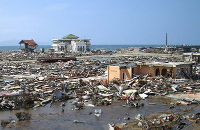
Waves and wave-carried debris devastated once-thriving communities, destroying homes, businesses, basic services, critical infrastructure, the environment, livelihoods, and entire economies. And the inundation of saltwater damaged soils, vegetation, and crops.
Together, the earthquake and tsunami changed the landscape of many Indian Ocean coastal communities. Coastal erosion and subsidence caused some shorelines to disappear into the ocean while, in some areas, uplift forced coral reefs to rise above its surface.
The Results

In 2004, if there had been a tsunami warning system for the Indian Ocean, better communications networks, and greater public understanding of tsunamis and how to appropriately respond to them, many tens of thousands of lives likely would have been saved.
When the tsunami struck, a tsunami warning system existed for the Pacific Ocean, and discussions had been underway for the creation of a warning system for the Indian Ocean.
The catastrophic tsunami highlighted the reality that tsunami disasters also happen outside of the Pacific and created global awareness and motivation to establish tsunami warning and mitigation systems around the world to ensure a tragedy like this never happens again.
Today, national tsunami warning centers have been established in countries in the Indian Ocean region to receive messages, assess threats, and issue warnings as part of the larger Indian Ocean Tsunami Warning and Mitigation System, which is led by Australia, India, and Indonesia. In addition, efforts have been introduced to better educate the public about the tsunami hazard.
Watch a story of survival from NOAA scientist Dr. Dwayne Meadows, who got caught in the tsunami while on vacation in Thailand.
More Information
- M 9.1 - Off the West Coast of Northern Sumatra, U.S. Geological Survey, Earthquake Hazards Program
- Pacific Tsunami Warning System: A Half-Century of Protecting the Pacific 1965-2015, International Tsunami Information Center (2015)
- Sumatra, Indonesia Earthquake and Tsunami, 26 December 2004, NOAA, National Centers for Environmental Information
- Tsunami Generation from the 2004 M=9.1 Sumatra-Andaman Earthquake, U.S. Geological Survey, Pacific Coastal and Marine Science Center
- Tsunami Teacher Resource Kit offsite link, United Nations, Educational, Scientific, and Cultural Organization (2006)

