Storm damage in Berlin Township, Ohio, from a derecho that moved through the region on June 13, 2022. This derecho is one of nine billion-dollar disasters to strike the U.S. so far in 2022. (Image credit: Neil Fischer/National Weather Service)
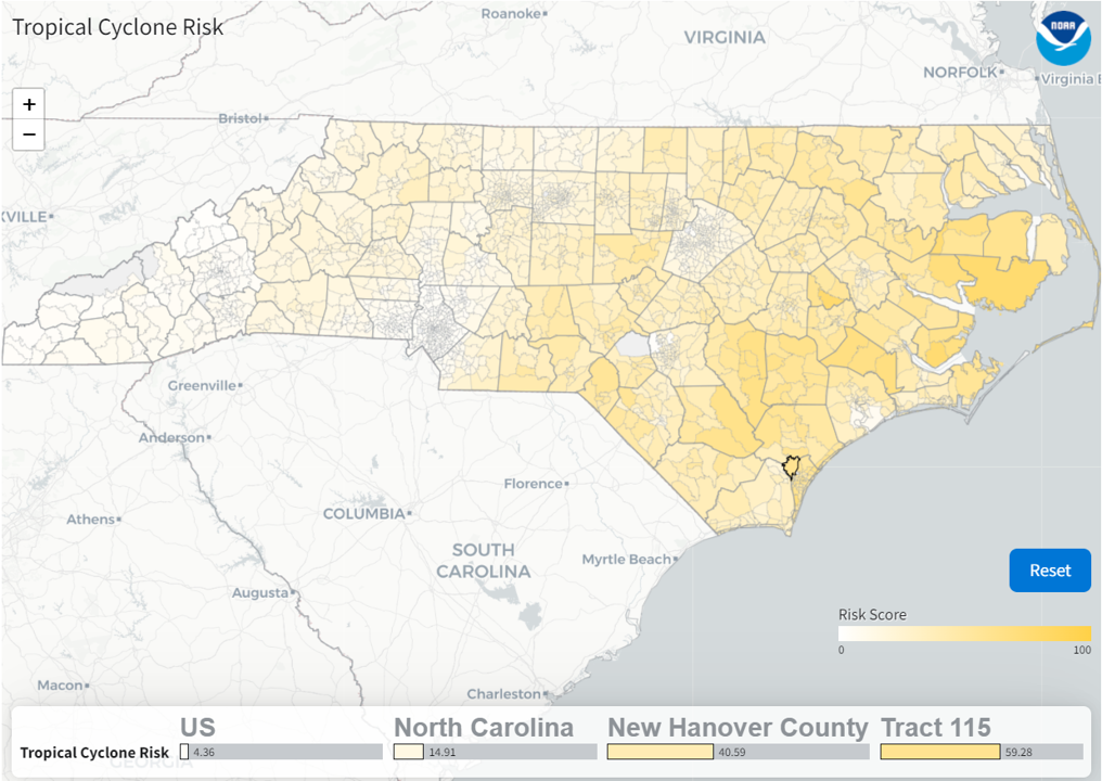
A comprehensive update to NOAA’s Billion Dollar Disasters mapping tool now includes U.S. census tract data – providing many users with local community-level awareness of hazard risk, exposure and vulnerability across more than 100 combinations of weather and climate hazards.
The enhanced interactive maps from NOAA’s National Centers for Environmental Information (NCEI) cover all 50 states and the District of Columbia, and provide data for over 72,000 U.S. census tracts, which are small subdivisions of counties that average about 4,000 inhabitants. Users can now visualize a community’s combined physical exposure, socioeconomic vulnerability and markers of resilience to natural hazards on a finer scale than ever before.
“The updated tool will provide a better understanding of how weather, ocean, and climate disasters impact many Americans at the community level, and help guide targeted preparation and mitigation efforts as we build a Climate-Ready Nation,” said NOAA Administrator Rick Spinrad, Ph.D.. “This hyper-local information advances NOAA's vision for resilient communities and economies, and will strengthen our support for vulnerable populations that face outsized weather, ocean and climate risks.”

The census tract data builds on county-level data added to the mapping tool last year. The weather and climate hazards displayed through the tool include severe storms and tornadoes; drought events and heat waves; hurricanes and tropical storms; wildfires; river-basin and urban flooding; and winter storms, freeze events and cold waves.
“This tool helps the public better understand potential impacts of disasters on the American people and our economy. It illustrates how combining resources from the Census Bureau and NOAA can advance each agency's mission,” said U.S. Census Bureau Director Robert L. Santos. “We are pleased to see American Community Survey data being used in this new tool. We're excited to collaborate with NOAA in the future on enhancements to the tool that incorporate even more of our data.”
The new maps also provide select socioeconomic vulnerability information using the CDC Social Vulnerability Index, which is derived from the Census Bureau’s American Community Survey data. There are numerous factors found in the census tract data that can indicate potential vulnerability, including:
- Socioeconomic status;
- Household composition and disability status;
- Minority status and language; and
- Housing type and transportation availability.
Examining this information can help to identify areas where both risk exposure and socioeconomic vulnerability is high. Decision-makers can then use this information to better understand where to focus hazard mitigation planning and investment, especially in areas where resources are sparse.
“This mapping tool helps people understand the risk of weather and climate disasters where they live–at a time when we’re seeing more costly extreme weather events,” said Adam Smith, billion-dollar disaster expert for NOAA NCEI. “For example, a user can explore multiple hazard risks, such as the cascading impacts of drought, wildfire and flooding on vulnerable populations in the U.S. Southwest or see how combined hurricane, flooding and severe storm events across the Gulf coast could severely impact their neighborhood.”
The new tool comes at a time when the number and cost of billion-dollar disasters in the U.S. are rising. Since January of 2020, the nation has experienced 51 separate billion-dollar weather and climate disasters, which totaled more than $275 billion in damages and killing nearly 1,000 people. From January to June 2022, the U.S. has already been impacted by nine separate billion-dollar disasters, a busy start to the year.


