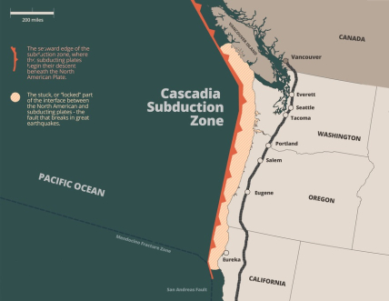
In recent decades, much tsunami and earthquake research has been focused on the coast of the Pacific Northwest, where more and more evidence points to large earthquakes and tsunamis in the past and the potential for more in the future. The source of these earthquakes and tsunamis is the Cascadia subduction zone, which lies mostly off shore and extends approximately 700 miles (1,100 kilometers) from Cape Mendocino in Northern California to Northern Vancouver Island, Canada.
The Cascadia subduction zone is where the Juan de Fuca, Explorer, and Gorda tectonic plates are subducting under the North American plate. It is now thought to be capable of producing great earthquakes of magnitude 8 or 9, like those off Indonesia in 2004 and Japan in 2011.
Before the mid-1980s, the tsunami hazard to the Pacific Northwest coast was thought to be from distant tsunamis - those that would come from afar with hours for warning and evacuation. Local tsunamis were of little concern.
This was primarily because there are no written records of such events, and it was believed the Cascadia subduction zone was not capable of producing great earthquakes. But now we know this region has experienced such earthquakes and tsunamis historically and is likely to again in the future.
January 27, 1700
On this date, a tsunami flooded the shores of Japan. There was no earthquake or other warning, and it would be almost 300 years before scientists and historians identified the source of this "orphan tsunami" as an estimated magnitude 9.0 Cascadia subduction zone earthquake.
This was achieved through analysis of historical records in Japan, Native American oral histories that tell of shaking, flooding, and destruction along the region's coast, geologic and natural history, and numerical tsunami models.
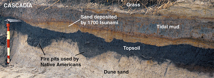
Geologic and natural history show that on this date, a great earthquake caused the coast along the subduction zone to rapidly subside three to six feet (one to two meters) and generated a large tsunami. Evidence for this and other historical earthquakes and tsunamis is found in offshore submarine landslide deposits.
Evidence is also found on shore in "ghost forests" and layers of sediment in coastal marshes and lakes that can only be explained by great earthquakes or their resulting tsunamis:
- Submarine landslides (turbidity currents) are shaken loose by ground shaking, and their presence shows that great earthquakes have occurred in the region.
- "Ghost forests" are found in tidal marshes and feature the remains of trees killed when the land subsided and saltwater rushed in. Rings of these trees tell the story of how and when they died.
- The buried remains of tidal marshes provide more evidence of subsidence, and layers of sand in coastal marshes and lakes overlying more typical soils, like peat, confirm tsunami inundation.
Evidence of Other Great Earthquakes and Tsunamis
While the 1700 tsunami was the most recent great earthquake and tsunami event to strike the region, it was not the only one.
These scientific records tell the tales of other similar earthquakes and tsunamis. In fact, scientists have estimated that over the last 10,000 years, more than 40 earthquakes greater than magnitude 8 occurred somewhere along the Cascadia subduction zone.

Like the 1700 event, at least 19 of these were around magnitude 9 and ruptured the entire length of the subduction zone. The southern section of the subduction zone south of Newport, Oregon, has historically been more active than the northern section.
Looking Ahead
It has been over 300 years since the 1700 event. In this time, stress has been building between the plates. Evidence suggests it may not be too long before the next great earthquake shakes the region.
We do not know when that will happen. It could be tomorrow, or it could be many years from now.
It could be a magnitude 9.0 "full rip" or a partial rupture (magnitude 8+). Either would have significant impacts.
Given the uncertainty, it is extremely important to understand the potential impacts of a Cascadia earthquake and any resulting tsunami and to prepare for them. Emergency managers are planning for an event similar to the 1700 earthquake and tsunami as described in a scenario document from the Cascadia Region Earthquake Workgroup (CREW). This scenario assumes:
- The earthquake will be felt throughout the Pacific Northwest,
- Shaking will last for four to six minutes,
- The coast will subside approximately six feet (two meters), and
- A tsunami will reach the coast in 15 to 30 minutes in some locations.
The height of the tsunami will vary along the coast depending on local bathymetry and topography. It may be as high as 30 to 40 feet (9 to 12 meters) in some places.
The amount of subsidence caused by the earthquake and the tide will also affect wave heights. Waves of varying heights will continue over a period of hours, and the first may not be the largest.
Flooding and dangerous currents may last for days. Additional hazards, like liquefaction (when soil liquefies during shaking), landslides, fires, dam failures, and hazardous material spills are also likely.
Should the earthquake and tsunami happen in the near future, it could affect millions of people, property, infrastructure, and the environment. According to the CREW scenario, the number of deaths could exceed 10,000, more than 30,000 people could be injured, and economic losses could approximate $70 billion for Washington, Oregon, and California alone.

Since most construction in the region was not designed to survive earthquakes, much less tsunamis, buildings will be damaged and destroyed, and businesses will be crippled. Impacts on important infrastructure associated with transportation networks (roads, bridges, railways, ports, and shipping channels), communications, utilities, energy networks, and public health and medical systems will be significant.
Many will be left homeless, and relief to coastal communities will be complicated and may take weeks to arrive. Basic services like electricity, water, and communications will be disrupted for long periods of time.
The tsunami will travel across the Pacific and bring flooding and strong currents to coastal communities throughout the basin from Alaska to as far away as Japan and the islands in between. Because it will take more time for the tsunami to reach these coasts, there will be more time for them to prepare and get to safety, and the impacts should not be as severe as those experienced in the Cascadia region.
What Is Being Done
It is not a matter of if but when the next significant Cascadia earthquake and tsunami event will occur. While these natural hazards cannot be stopped, their impacts can be reduced.
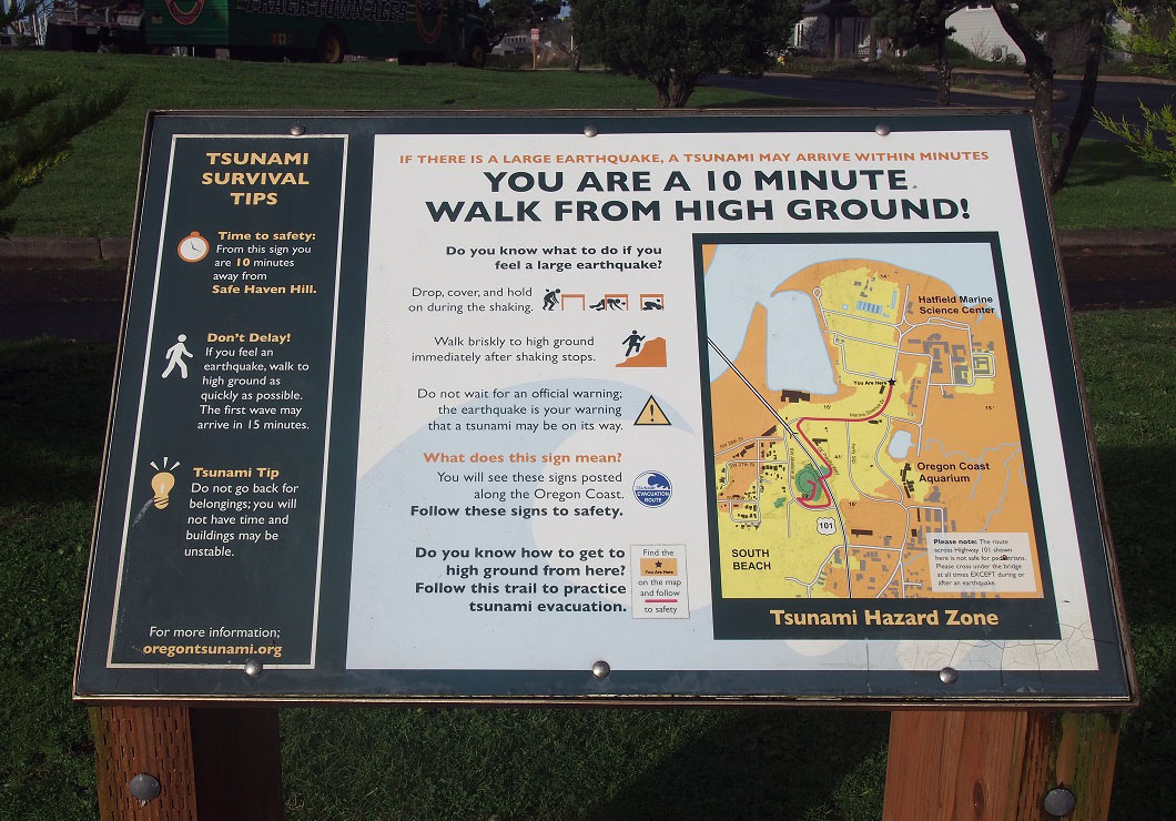
Scientists, engineers, and public officials are working together to better understand the threat and prepare coastal communities to better withstand such an event. Efforts include identifying tsunami inundation areas; mapping evacuation zones; establishing evacuation routes, assembly areas, and structures; posting tsunami hazard zone and evacuation signage; educating the public about preparedness and response practices; setting up local warning systems; adopting stronger building codes; and strengthening older buildings and structures.
Do you live in the Cascadia region? If so, learn how you can prepare.
Resources
- Cascadia Subduction Zone Earthquakes: A Magnitude 9.0 Earthquake Scenario (pdf), Cascadia Region Earthquake Workgroup (2013)
- The Orphan Tsunami of 1700 - Japanese Clues to a Parent Earthquake in North America, 2nd edition (pdf), U.S. Geological Survey and University of Washington Press (2015)
- Subduction Zone Earthquakes off Oregon, Washington More Frequent than Previous Estimates offsite link, Oregon State University (news release, Aug. 5, 2016)
- 13-Year Cascadia Study Complete - and Earthquake Risk Looms Large offsite link, Oregon State University (news release, Aug. 1, 2012)
- Turbidite Event History - Methods and Implications for Holocene Paleoseismicity of the Cascadia Subduction Zone (pdf), U.S. Geological Survey Professional Paper 1661-F (2012)

